A continuing series with photos and impressions of our 25-day trip to Ireland and England. Click on images for an enlarged view.
We packed up our things and checked out, but just for one night. We would spend the night in Portrush and come back the next day, returning to the same hotel in Belfast for the remainder of the week. We drove past Carrickfergus, (see report here) where we had visited last week, and on up to the northern end of the island. There were a couple of tunnels that reminded us of the old tunnels along Madeira’s coast line.

But the old tunnels in Madeira are longer, and the new ones, longer yet (up to 2 miles/3 km long). The rolling green fields with the “wee sheep”, the yellow gorse and the blooming hawthorn hedges were becoming a familiar sight to us.

Carrick-a-Rede
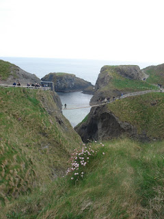
The name means “rock in the road” (Carrickfergus = “Fergus’s Rock”) and refers to a small rock islet used by salmon fisherman. It is separated from the mainland by a 60-foot (18m) gap that the fishermen spanned by means of a rope bridge. There are still some vestiges of the fishing activity  where the original method used was to set the nets on one side of the little island, then drive the salmon towards the nets by throwing rocks into the sea from the cliffs 80 feet (25m) above. (Would that make them "salmonherders" or "salmon drivers"?) Today the site is a tourist attraction and accordingly, the rope bridge has been upgraded by adding more ropes on the sides and boards to walk across on. The fishermen’s version would have been a modified tightrope, probably. This arrangement is daunting enough for the uninitiated, and if the wind is blowing hard (as it was when we were there) it can be a challenge for even the more adventurous.

Cary has to hold on to his hat instead of the rope.

 The island is covered with flowers and birds that nest on its cliffs. At times the cries of the thousands of birds of various species almost became a din, "raucous birds on the rocks," you could say.
 Here is an enlarged view of the cliff where the birds are well camouflaged.
The whitewash on the rocks is exactly what you think it is.
 But there were quieter species, as well.

 The island in the background is accessible only by boat and was used in the past for grazing sheep. How large is it? According to the rule of thumb of the shepherds, it was “large enough to fatten 10 sheep, feed 11, and starve 12.” Just getting the sheep in and out of the boats and up and down the cliffs must have been a real job. We did catch a glimpse of Rathlin Island on the horizon, which is part of Scotland. It’s no wonder there are such close ties between N. Ireland and Scotland. Remember the Ulster-Scots sign at Downpatrick? (See note on this posting.) I browsed through a newspaper at one of the shops, and found an article defending the use of the term “Ulster-Scots” by those living in the Ulster province of N. Ireland, as opposed to the term “Scotch-Irish” used by their cousins just a few miles away across the Irish Sea.
These close ties were not always friendly ones, however, as we would learn later at nearby Dunluce Castle.
 The castle made use of a 30m-high basalt outcropping separated from the mainland by a gap that served as a natural “moat” spanned by a bridge that could easily be defended from the towers of the castle. Originally built in the 14th century, it was assaulted on more than one occasion by marauding clans from Scotland. Further additions were made in the 16th and 17th centuries by the MacDonnells, an offshoot of the Scottish clan McDonald, when it was the residence of nobility. But what attacking armies could not do, the relentless sea has done. One night in 1639, a grand dinner was interrupted by a deafening sound, and guests rushed to the back of the castle to find that the back wall of the castle had fallen into the sea 100 feet below, taking with it a large part of the kitchen and some of the ladies working there. The sea continues to erode the rocky cliffs on which the castle is built and engineers are working to halt the process.
 View of the coast from a hole in the wall, where an oven built into the wall fell off in more recent times.

Engineers use mountain-climbing technology as they inspect the cliffs
and try to prevent more of the castle from falling down.
Some of us men went to explore the cave under the rock the castle is built on. It had all the makings of being a pirate’s hideout (like in the movies), but if there was ever any treasure there Paul, Cary and I got there too late.


There was also a brief stop at White Park Bay, where some of us strolled along the sandy beach. Not too many people out getting a sun tan while we were there. Abbie, however, went prepared with her beach attire.


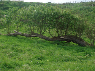
A couple of curiosities I found here were a rock on the beach with the same colors of the sand, which was two-toned, and a fallen tree that illustrates that old saying, “You can’t keep a good tree down.”


Portrush
 We spent one night in this town, with the Methodist Church prominent in the center of things. Along the street there was a string of arcades and tourist shops, a sign that later in the summer there would be an influx of tourists to the coastal town. That would explain, in part, this sign, although I don’t know to what extent the Evangelistic Mission and the Beach Toilets are related.

C.S. Lewis’s mother would bring him and his brother up to this area to spend summer holidays, and I could imagine this house as having been built to accommodate holiday-makers coming up from Belfast for the summer. There is a pool behind it. I never learned the story of this building, how old it is, or who built it, but its style and setting are reminiscent of the old spas and resorts.

The other interesting feature of this down was the brick commemorative column, with representations of the various eras of occupation of this area over the centuries.


 The plaque at the foot of the column explains how it was carved. The raw bricks were stacked, sculpted, then the column was disassembled and the pieces numbered and fired in a kiln before being reassembled. Something like a giant 3-D puzzle, but I bet those who put it back together cheated and looked at the answer key.


0 Comments:
Post a Comment
<< Home